


Imelda and Humberto: Unleashing Turbulence in the Atlantic


Atlantic Turmoil: Imelda and Humberto’s Impact
As September 2025 drew to a close, the Atlantic Ocean was alive with activity from two major tropical systems, Imelda and Humberto. Although these storms were expected to stay over open waters, they still brought intense rain, powerful winds, and dangerous surf to areas like the northern Caribbean, the Bahamas, Bermuda, and the eastern United States.
Storms Captured from Space
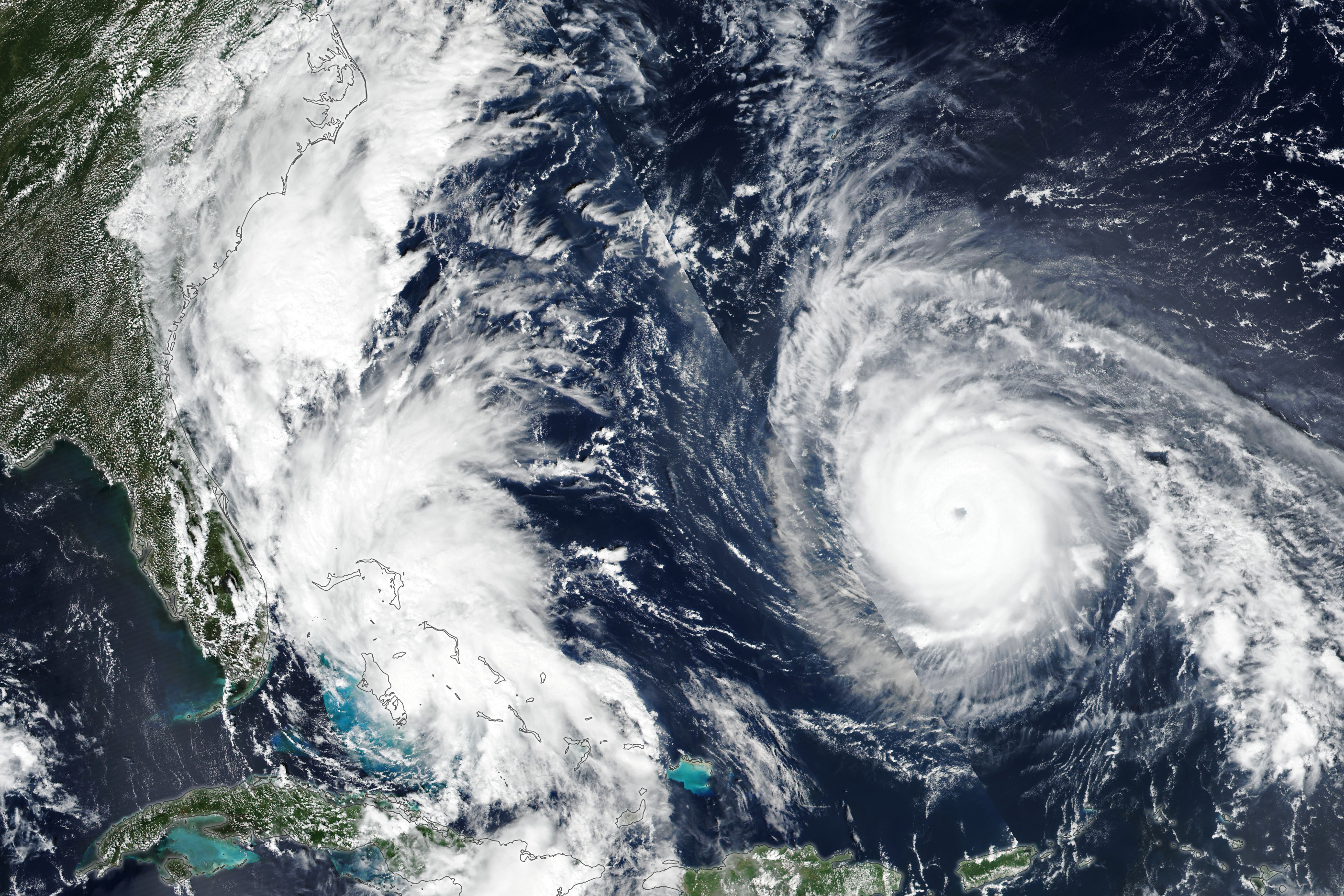
The VIIRS instrument on the Suomi NPP satellite captured a remarkable image on September 28, showing both Tropical Storm Imelda and Hurricane Humberto. At that moment, Imelda was moving northward through the Bahamas with winds of 40 mph (64 kph). Meanwhile, Humberto was about 700 miles (1,100 km) east of the Bahamas, heading northwest with maximum winds of 150 mph (240 kph), making it a Category 4 hurricane. Just a day earlier, Humberto had reached Category 5, becoming the second hurricane of the season to reach such strength.
Imelda’s Path and Potential Growth
Imelda had already affected the central and northwestern Bahamas with tropical storm conditions. Before being named, it had also brought heavy rain to Puerto Rico and eastern Cuba. The National Hurricane Center indicated that Imelda might intensify, possibly leading to flash and urban flooding along the Carolinas’ coast in the coming days.
Humberto’s Wide-Reaching Influence
Despite Humberto’s distance from land, its large size meant its effects were felt along coastlines. Hazardous surf conditions were reported across beaches in the northern Caribbean, the Bahamas, and Bermuda, extending to much of the U.S. East Coast. Forecasters warned that mid-Atlantic and even some northeastern states could experience large swells and rip currents due to the storm, as noted by weather experts.
Forecasting Complexities and the Fujiwhara Effect
While Imelda’s impact on the U.S. Atlantic Coast might be less severe than initially expected, Humberto’s proximity could influence Imelda’s trajectory, potentially pulling it away from the shore. This interaction between nearby tropical cyclones is a rare phenomenon known as the Fujiwhara Effect. This complex dynamic poses challenges for forecasters, but as of the morning of September 29, Imelda was projected to veer sharply to the east-northeast. Notably, no Atlantic hurricanes have made landfall in 2025 so far.
Stay Informed and Prepared
In times of severe weather, it’s crucial to stay informed through reliable sources. Avoid spreading or believing in rumors, and follow official alerts only. Stay calm, keep updated, and adhere to guidance from local authorities. Preparedness and caution can make a significant difference in ensuring safety during such events.
Image courtesy of NASA Earth Observatory by Lauren Dauphin, utilizing VIIRS data from NASA EOSDIS LANCE, GIBS/Worldview, and the Suomi National Polar-orbiting Partnership. Article by Lindsey Doermann.
What's Your Reaction?
 Like
0
Like
0
 Dislike
0
Dislike
0
 Love
0
Love
0
 Funny
0
Funny
0
 Angry
0
Angry
0
 Sad
0
Sad
0
 Wow
0
Wow
0