


Unveiling Winter’s Magic: The Transformation of the Mississippi River Delta


Viewing the Mississippi River Delta from Above
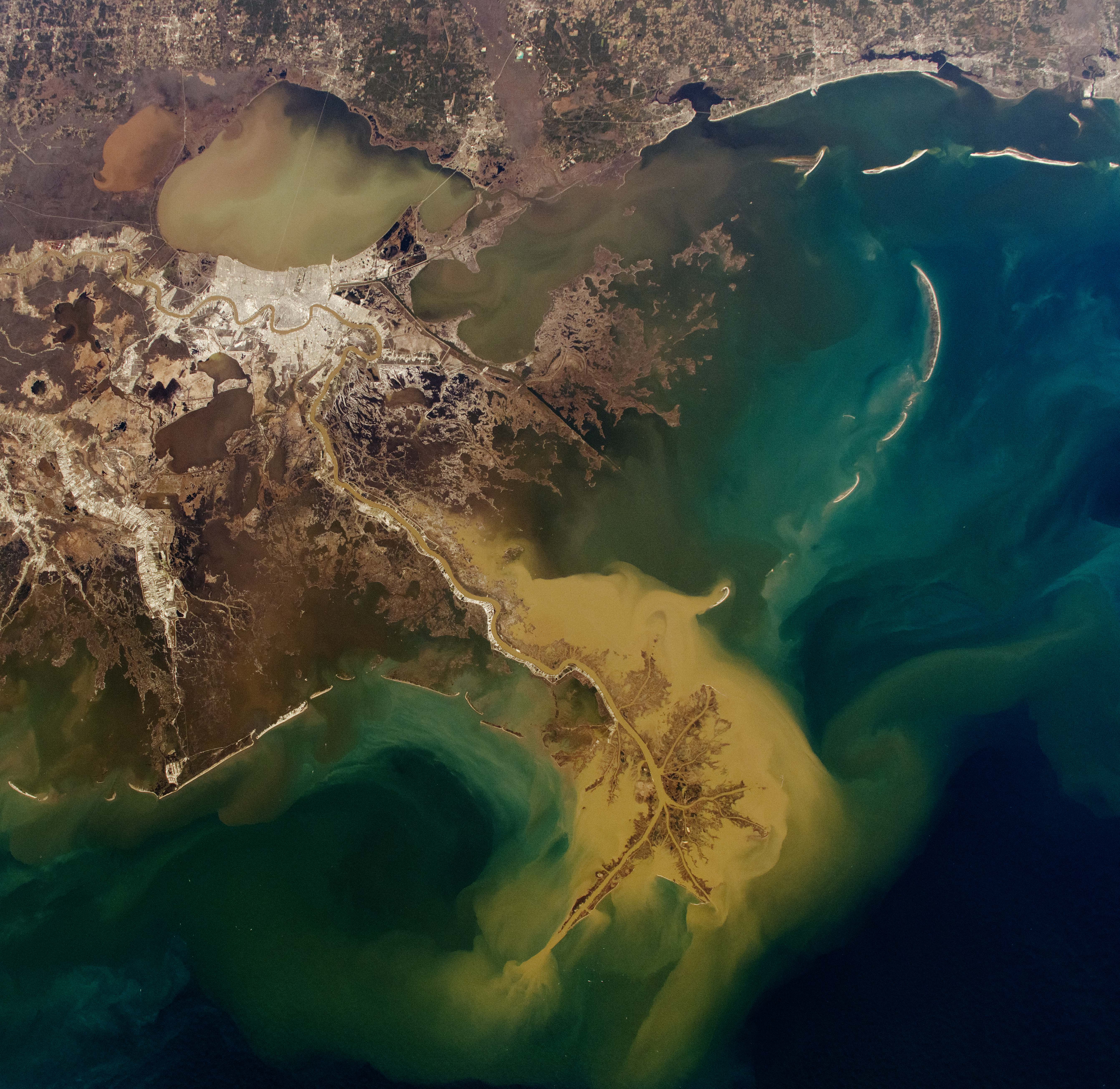
An astronaut on the International Space Station captured a breathtaking image of the Mississippi River Delta, where the river flows through New Orleans, Louisiana, before expanding into a sprawling delta.
Formation and Characteristics of the Delta
The delta extends from the river’s mouth into multiple channels, creating the distinctive bird’s foot pattern of the Mississippi River Delta Basin. These channels eventually merge with the Gulf of Mexico. The sediment-rich waters, visible as light-tan plumes, blend with the ocean’s blue tones. Between the mainland and the delta, dark marshlands and peat formations are evident, while barrier islands, shaped by longshore currents, line the coast.
Recent Weather Impacts
From January 20 to 22, 2025, a major storm hit the Gulf Coast. Snow, an unusual occurrence in this area, blanketed the landscape until January 24, when this image was taken. The melting snow likely caused a temporary rise in the Mississippi River’s outflow, affecting the sediment plumes around the delta.
The River’s Path and Impact
Starting at Lake Itasca in Minnesota, the Mississippi River travels about 3,770 kilometers (2,340 miles) through ten states before reaching the gulf. The delta is a dynamic area where land formation, channel shifts, and water inundation occur. The delta’s development is significantly influenced by river sediment, but human activities, rising sea levels, and erosion also play crucial roles.
Economic and Environmental Importance
The Mississippi River’s watershed encompasses 41% of the United States, touching 31 states and extending into two Canadian provinces. Its nutrient-rich waters support fertile agricultural lands and are vital to the U.S. economy by providing essential shipping routes. To maintain these functions, engineers have implemented channelization and sediment diversion projects to restore critical sediments to the wetlands.
Challenges and Adaptations
Flooding from storms and rising sea levels has led to the construction of levees, dams, and floodwalls over the past two centuries. As the Mississippi River and its delta continue to reshape the landscape, ongoing modifications are necessary to maintain navigable waterways.
This photograph, ISS072-E-575684, was taken on January 24, 2025, using a Nikon Z9 camera with a 50mm lens. It is provided by the ISS Crew Earth Observations Facility and the Earth Science and Remote Sensing Unit at Johnson Space Center. Captured by a member of the Expedition 72 crew, the image has been enhanced for contrast. The International Space Station Program supports this initiative as part of the ISS National Lab, aiming to provide valuable images for scientists and the public. More images can be found at the NASA/JSC Gateway to Astronaut Photography of Earth. Caption by Elysia Viengkham, Amentum-JETS II Contract at NASA-JSC.
What's Your Reaction?
 Like
0
Like
0
 Dislike
0
Dislike
0
 Love
0
Love
0
 Funny
0
Funny
0
 Angry
0
Angry
0
 Sad
0
Sad
0
 Wow
0
Wow
0